Santiago Island - Trails and trekking
Santiago Island Hiking and Trekking
Trails by Region (2025)
Introduction: Santiago's Diverse Hiking Landscape
Santiago Island, the largest and most mountainous island in Cape Verde, offers exceptional hiking across distinct geographical regions. From the cloud forests of the northern mountains to the UNESCO-listed coastal settlements in the south, each region presents unique landscapes, microclimates, and trail experiences.
This guide organizes Santiago's hiking trails by geographical region, helping you navigate the island's diverse terrain and plan routes based on location rather than difficulty alone.
Best Time for Hiking on Santiago Island
Dry Season (November–June): Moderate temperatures (23-28°C), minimal rainfall, dry trails, clear summit views. Best months: January-March for coolest conditions.
Post-Rainy Season (July–September): Lush green landscapes, flowing waterfalls, excellent birdwatching. Most rainfall: August-October.
Shoulder Season (October–December): Green post-rain landscapes without heavy precipitation—ideal for photography.
Daily timing: Start hikes early (7-8am) or late afternoon (after 4pm) to avoid midday heat.
Region 1: Northern Mountains - Serra Malagueta Area
Location and Geography
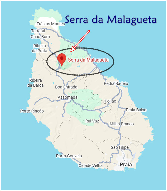
The Serra Malagueta region dominates Santiago's northern highlands, reaching elevations up to 1,064m. Located approximately 30km north of Praia and 20km south of Tarrafal, this mountainous area is protected as the Serra Malagueta Natural Park (PNSM). The region is characterized by dramatic valleys, cloud forests, endemic vegetation, and traditional mountain villages connected by ancient footpaths.
Climate and Landscape
The northern mountains capture moisture from Atlantic winds, creating misty, lush conditions distinct from Santiago's drier southern regions. The park harbors over 124 plant species (28 endemic) and serves as a sanctuary for endemic bird species including the Cape Verde warbler and Iago sparrow.
Trails in Serra Malagueta Natural Park
Ribeira Principal Valley Trail
Route description: Begins at the park entrance (approximately 850m elevation) and descends into the verdant Principal Valley. The trail winds through local farms cultivating bananas, sugarcane, corn, and beans, passing traditional grogue distilleries and offering glimpses of rural Santiago life.
Distance: 6-10km (varies by route) Duration: 2-4 hours Terrain: Descending valley trail with some slippery, narrow sections Features: Waterfalls and natural swimming holes (best July-October), agricultural terraces, endemic flora
Note: Remote valley sections are poorly marked; local guides recommended for navigation.
Gongon Trail to Hortelão Village
Route description: Starts at the Serra Malagueta park entrance and descends through the Gon Gon Valley, ending at the village of Hortelão. The path passes small mountain settlements, tropical fruit orchards (mango, papaya, breadfruit), and traditional grogue distilleries.
Distance: 10.5km (6.5 miles) Elevation change: 1,000m descent (3,300 feet) Duration: 4-6 hours Features: Cultural encounters with village life, fruit orchards, endemic birdwatching opportunities
Pico Malagueta Summit Trail
Route description: Ascends to the summit of Pico Malagueta within the natural park, offering panoramic views over northern Santiago's valleys and the Atlantic coastline.
Distance: ~8km round trip Elevation gain: 600m Duration: 3-4 hours Features: Breathtaking summit panoramas, endemic bird habitats, cloud forest vegetation
Monte Tchota Trails
Location: Within the Monte Tchota Natural Park section of the greater Serra Malagueta area Features: Network of trails through protected montane forests Access: Often approached via Rui Vaz village
Region 2: Central Mountain Massif - Pico da Antónia Area
Location and Geography
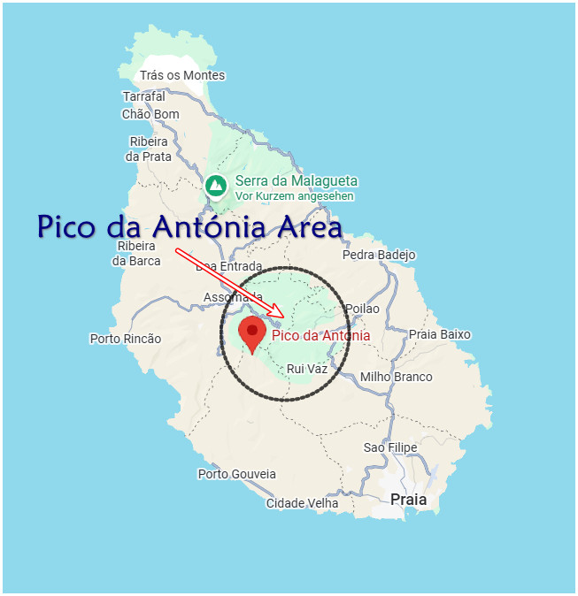
The Pico da Antónia massif dominates Santiago's central highlands, with the island's highest peak (1,392m) as its centerpiece. This region lies inland from Praia, accessible primarily through the mountain village of Rui Vaz. The area is protected as Parque Natural da Serra do Pico de Antónia and features rugged, alpine-like terrain with jagged peaks, eucalyptus forests, and sisal plantations.
Climate and Topography
As Santiago's highest elevation zone, this region experiences cooler temperatures, frequent mist and clouds, and dramatic temperature variations between day and night. The terrain is notably more rugged and exposed than Serra Malagueta, with steep ridges and loose scree in upper elevations.
Trails in the Pico da Antónia Region
Pico da Antónia Summit Route
Route description: The classic route begins near Rui Vaz village, climbing through Monte Tchota Natural Park. The 800m ascent from Rui Vaz follows narrow, steep paths through eucalyptus groves. The final approach to the summit traverses an exposed ridge running close to eastern cliffs.
Starting point: Rui Vaz village Summit elevation: 1,392m (some sources: 1,394m or 1,395m) Distance: 9-15km round trip (varies by route) Duration: 4-7 hours total Terrain: Steep paths, loose rock and scree in upper sections, exposed summit ridge Views: 360° panorama including entire Santiago Island, Fogo volcano (west), Maio Island (east)
Technical notes: Paths unclear in places, surefootedness required on summit ridge, navigation skills essential in mist.
Pico da Antónia Foothills Circuit
Route description: Rather than summiting, this route follows the foothills of Pico da Antónia, passing through eucalyptus forests and sisal plantations surrounded by jagged peaks, eventually descending toward Assomada.
Distance: 17km (10.6 miles) Elevation: 610m ascent, 870m descent (2,000'/2,850') Duration: ~6 hours Features: Less technical than summit route, excellent views without exposure, connection to Assomada
Region 3: Central Interior - Assomada and Santa Catarina area
Location and Geography
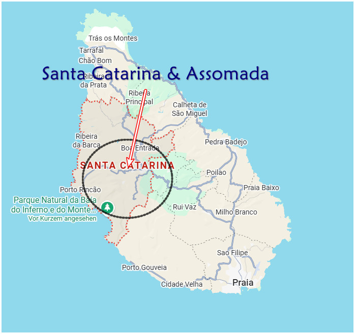
Assomada, Santiago's second-largest town, sits in the island's central interior at a moderate elevation. This region encompasses the surrounding plateau areas and river valleys (ribeiras) of Santa Catarina municipality. The landscape consists of agricultural plateaus, river valleys with dramatic gorges, and traditional rural villages.
Character of the Region
This is Santiago's agricultural heartland, where terraced farms produce much of the island's fresh produce. The region offers intimate glimpses of rural Cape Verdean life, with traditional architecture, livestock herding, and weekly markets (Assomada's market is most active Wednesdays and Saturdays).
Trails Around Assomada and Santa Catarina
Ribeira de Santa Cruz Trail
Route description: Follows the Santa Cruz river valley toward the Cancelo banana cooperative, passing through agricultural areas and riverside vegetation.
Features: Working banana cooperative visit opportunities, river valley scenery, agricultural landscapes
Ribeira de Picos Valley Route
Route description: Traces the Picos river valley through traditional farming areas and small villages.
Features: Authentic rural experience, traditional Cape Verdean agriculture, quiet valley walking
Poilão Kapok Tree Walk
Route description: Leads to the Poilão, Cape Verde's oldest kapok tree, with options for longer plateau trails that descend toward the coastal road.
Features: Ancient kapok tree (significant natural monument), plateau vistas, extension options for longer walks
Ribeira da Barca Valley Trail
Location: Northwest of Assomada Route description: Traverses the dramatic Ribeira da Barca valley, known for its impressive cave systems.
Distance: 11.47km running trail variant Elevation gain: 301m Features: Dramatic valley landscapes, Águas Belas caves (Grutas Águas Belas) accessible by boat from the coastal village of Ribeira da Barca
Rincão Trail to Grutas Águas Belas
Distance: 11.47km Elevation gain: 301m Destination: Águas Belas caves Character: Running/hiking trail through interior valleys
Region 4: Western Coast - Cidade Velha and Calabaceira area
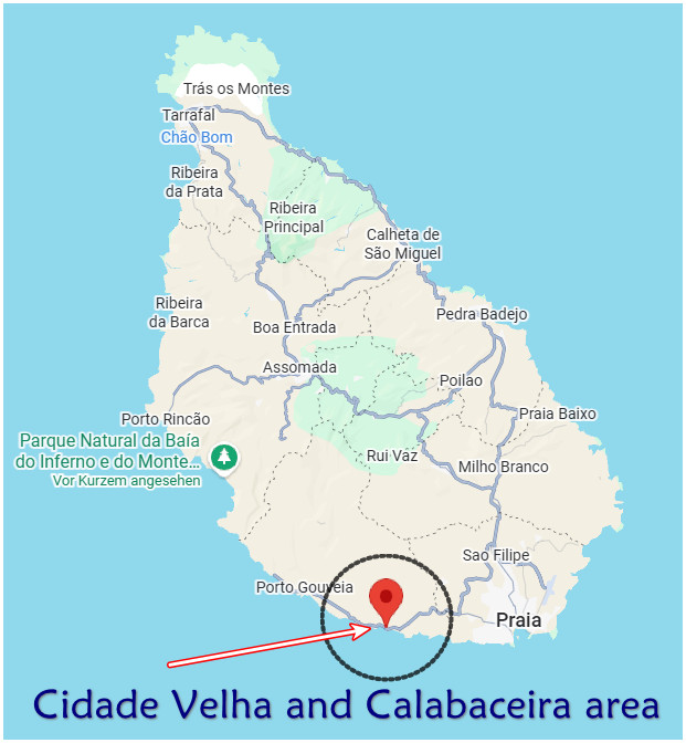
Location and Geography
This region encompasses the western coastal area south of Praia, centered on the UNESCO World Heritage Site of Cidade Velha (formerly Ribeira Grande de Santiago). Located just 10km west of the capital, this historic area features dramatic valleys descending from the interior highlands to the Atlantic coast.
Historical and Natural Significance
Cidade Velha, founded in 1462, was Cape Verde's first settlement and capital. The region combines colonial heritage with lush valley landscapes where intensive agriculture thrives due to seasonal water flow and protected valley microclimates.
Trails in the Cidade Velha Region
Calabaceira Valley to Cidade Velha Route
Starting point: Calabaceira village (also called "Green Valley") Ending point: Cidade Velha coastal town Distance: 4km Elevation change: 200m descent, 0m ascent Duration: 2-4 hours (including stops)
Route description: Descends through a valley rich with tropical plantations including banana, mango, papaya, and traditional sugarcane cultivation. The trail passes a famous 400-year-old baobab tree and traditional grogue distilleries where Cape Verde's national rum is produced using centuries-old methods.
Destination features: Trail ends in Cidade Velha's UNESCO-listed historic center, including:
- Fortaleza Real de São Filipe (16th-century fortress)
- Rua Banana (one of Africa's oldest colonial streets)
- Igreja de Nossa Senhora do Rosário ruins
- Pelourinho Square
- Sé Catedral ruins
Cidade Velha Urban Walking
Area: Historic center of Cidade Velha Features: Self-guided walking through cobblestone streets, colonial architecture, fortifications, churches, and waterfront areas Duration: 2-3 hours for comprehensive exploration Best time: Late afternoon for "golden hour" photography, especially near Fortaleza de São Filipe
Region 5: Northern Coast - Tarrafal Area
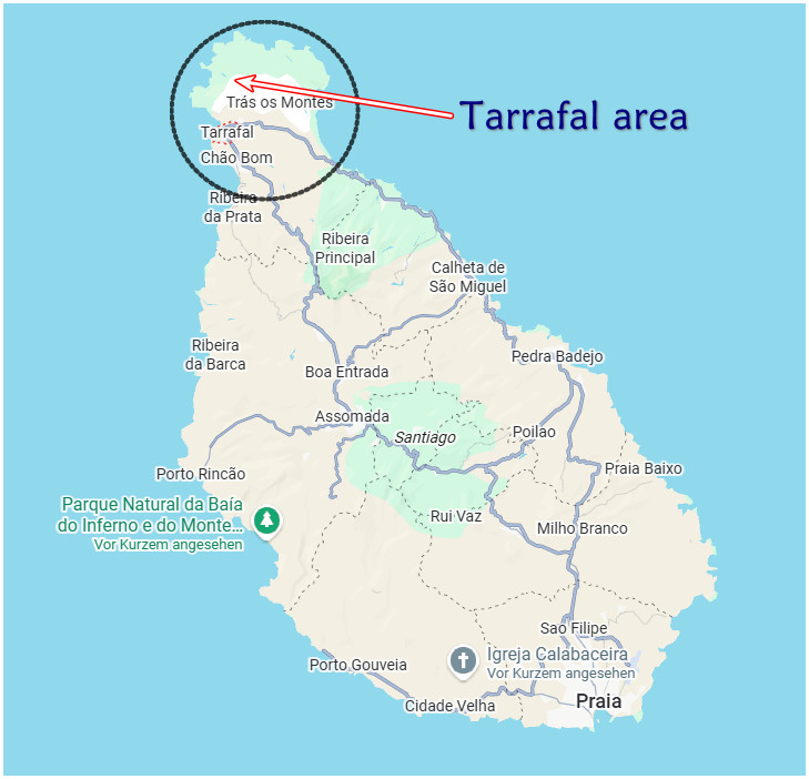
Location and Geography
Tarrafal occupies Santiago's northern tip, approximately 70km north of Praia via the main island highway through Assomada. This coastal region features Santiago's most famous beach (Praia do Tarrafal) backed by Monte Graciosa and surrounding hills. The area transitions from coastal flatlands to mountainous terrain within short distances.
Regional Character
Tarrafal serves as both a beach resort town and a gateway to northern hiking routes. The region offers unique combinations of coastal and mountain landscapes, with red dirt trails through the interior hills contrasting with the white sand beach and turquoise waters of Tarrafal Bay.
Trails in the Tarrafal Region
Monte Graciosa Coastal Circuit
Starting point: Tarrafal sandy beach Route type: Loop trail circumnavigating Monte Graciosa Distance: 10.9km Duration: ~5 hours Terrain: Partly unmarked and trackless—navigation experience required Features: Spectacular views over Baía de Tarrafal, coastal cliffs, Atlantic panoramas
Tchom Bom to Ribeira Prata Coastal Walk
Route description: Village-to-village coastal walk connecting two settlements in the Tarrafal area.
Duration: 2-3 hours Character: Coastal scenery, traditional fishing village culture
Tarrafal to Campo de Concentração
Distance: Short walk (a few minutes from Tarrafal center) Destination: Historical concentration camp museum (Campo de Concentração do Tarrafal) Character: Historical site visit accessible by easy walking
Region 6: Eastern Coast - Calheta de São Miguel area
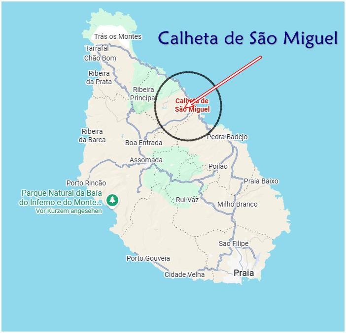
Location and Geography
The eastern coast of Santiago, particularly around Calheta de São Miguel, offers coastal walking routes distinct from the western settlements. This region faces the open Atlantic and features dramatic coastal landscapes with less development than other areas.
Trails in the Eastern Coastal Region
Calheta de São Miguel Coastal Route
Route description: Coastal path through the eastern shore area, offering Atlantic views and traditional coastal community interactions.
Character: Ocean scenery, coastal cliffs, fishing village culture Terrain: Coastal trail with ocean exposure
Region 7: Urban Areas - Praia
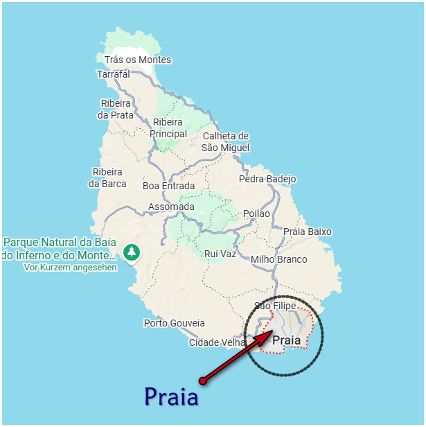
Location and Geography
Praia, Cape Verde's capital and largest city, occupies the southern coast of Santiago. The historic Plateau district sits on elevated terrain above the port and modern city center, offering walkable colonial-era streets and architecture.
Urban Walking in Praia
Plateau District Walking Tour
Area: Historic center of Praia (Plateau neighborhood) Features: Colonial architecture, governmental buildings, churches, plazas, cafés Key sites:
- Palácio Presidencial (Presidential Palace)
- Palácio da Assembleia
- Igreja de Nossa Senhora da Graça
- Statue of Diogo Gomes
- Colonial-era streets and plazas
Duration: 2-4 hours for comprehensive exploration Best time: Early morning or late afternoon
Mercado de Sucupira Area
Location: Below Plateau district Character: Walking through Cape Verde's largest street market and surrounding urban neighborhoods Best time: Mid-morning when market is most active
Coastal Praia Walks
Areas: Prainha beach area, Praia Quebra Canela, Praia da Gamboa Character: Urban beach walking, waterfront promenades
Practical Hiking Information
Trail Conditions and Navigation
Current reality: Most Santiago trails are not marked as dedicated hiking paths—they are utility trails used by local farmers and residents. Signage is minimal or absent on most routes. Navigation can be challenging in rugged valleys where multiple unmarked paths branch in different directions.
Improvement projects: The RTBED project is financing trail improvements and signage installation on several Cape Verde islands, potentially including Santiago.
Guide Services
Where guides are especially valuable:
- Pico da Antónia (unclear paths, safety on summit ridge)
- Ribeira Principal (remote area, easy to get lost)
- Serra Malagueta remote valleys (trail-finding)
- Any first-time hikes in unfamiliar regions
Finding guides:
- Hotels and guesthouses in Praia, Assomada, Tarrafal
- Serra Malagueta Natural Park entrance
- Tour operators based in Praia
- Local arrangements through accommodation
Essential Gear
Footwear: Sturdy hiking boots with good tread (loose rock, scree, uneven terrain) Water: 2-3 liters minimum—no reliable water sources on trails Sun protection: Hat, sunscreen, sunglasses (year-round essential) Navigation: GPS device or smartphone with offline maps Clothing: Layered system for elevation/temperature changes Safety: First aid kit, emergency contacts, local guide contact information
Permits and Fees
Serra Malagueta Natural Park: Entrance fee required (pay at park entrance) Pico da Antónia Natural Park: May require permit—verify before hiking
Regional Access and Starting Points
Reaching Hiking Regions from Praia
Serra Malagueta (North):
- Aluguer (shared minivan): Praia → Assomada → Serra Malagueta park entrance
- Private taxi: ~6,000 CVE to Tarrafal area (can arrange drop-off at trailheads)
- Car rental: ~45-60 minutes drive via main highway
Pico da Antónia (Central):
- Aluguer: Praia → Assomada, then arrange local transport to Rui Vaz
- Private taxi/arranged transport: Most practical for Rui Vaz access
- Tour operators: Often include transportation in guided packages
Assomada Trails (Central Interior):
- Aluguer: Praia → Assomada (~600 CVE, frequent departures)
- Depart from Mercado de Sucupira or Estádio da Várzea area in Praia
Cidade Velha/Calabaceira (West):
- Aluguer: Praia → Cidade Velha (~200 CVE)
- Taxi: ~1,000 CVE
- Distance: Only 10km from Praia—easily accessible
Tarrafal (North):
- Aluguer: Praia → Tarrafal (~600-700 CVE, 2-3 hours)
- May require change in Assomada or wait for direct service
- Accommodation available in Tarrafal for multi-day northern exploration
Accommodation by Region
Praia base: Hotels and guesthouses throughout capital—convenient for day trips to all regions
Assomada area: Local guesthouses and pousadas—ideal for multi-day interior hiking
Tarrafal: Beach hotels and residences—best for northern trails and coast access (e.g., Residence Tarrafal)
Strategy: Many hikers stay in Praia for accessibility and arrange day trips, or split accommodations between Praia (south), Assomada (interior), and Tarrafal (north) for comprehensive coverage.
Quick Reference: Santiago Trails by Region
Northern Mountains (Serra Malagueta): Ribeira Principal, Gongon Trail, Pico Malagueta, Monte Tchota
Central Mountains (Pico da Antónia): Summit route, foothills circuit
Central Interior (Assomada): Ribeira de Santa Cruz, Ribeira de Picos, Poilão walk, Ribeira da Barca
Western Coast (Cidade Velha): Calabaceira Valley walk, UNESCO site urban walking
Northern Coast (Tarrafal): Monte Graciosa circuit, Tchom Bom to Ribeira Prata, coastal walks
Eastern Coast: Calheta de São Miguel coastal route
Urban (Praia): Plateau district, market areas, coastal promenades
Access hub: Praia (capital) connects to all regions via aluguer, taxi, or rental car
Guide Services: When and Why
Recommended (Often Essential):
- Pico da Antónia: Unclear paths, safety concerns on summit ridge
- Ribeira Principal: Remote area, easy to get lost
- Serra Malagueta remote sections: Trail-finding in valleys
- Birdwatching focus: Guides spot endemic species and provide ecological knowledge
Optional but Beneficial:
- Calabaceira to Cidade Velha: Adds cultural context, grogue distillery access
- Gongon Trail: Navigation assistance, village interactions
- Any first-time hike: Local knowledge enhances experience
Independent Hiking Suitable:
- Malagueta main trails: Well-used paths (though guides enhance experience)
- Urban walking: Praia Plateau, Cidade Velha streets
- Short coastal walks: Tarrafal area
Finding Guides:
- Book through hotels/guesthouses in Praia, Assomada, or Tarrafal
- Tour operators in Praia (many hotels have partnerships)
- Serra Malagueta Natural Park entrance (guides often available)
- Online platforms: Cabo Verde hiking tour companies
Typical costs: €30-60 per person for group tours, €80-150 for private guide (full day)
Weather and Climate Considerations
Temperature by Elevation:
- Coastal areas: 25-30°C (dry season), warm year-round
- Mid-elevation (500-800m): 20-25°C, more comfortable for hiking
- Summit areas (1,000m+): 15-20°C, can be cool and windy
Microclimates: Santiago's mountains create distinct zones:
- Dry southern lowlands: Arid, hot, sparse vegetation
- Mountain zones: Capture moisture, create mist and clouds
- Northern valleys: Lusher, greener, more precipitation
Rain patterns:
- July-October: Sporadic but sometimes intense rainfall
- Peak months: August-October (80% of annual rain)
- Flash flood risk: Avoid valley hiking during or immediately after heavy rain
Combining Hiking with Other Santiago Activities
Santiago's diversity allows hikers to mix mountain adventures with other experiences:
Perfect Combinations:
Mountain + Beach:
- Morning: Serra Malagueta hike
- Afternoon: Tarrafal Beach swim
- Evening: Fresh seafood in Tarrafal
Culture + Nature:
- Day 1: Cidade Velha UNESCO sites
- Day 2: Calabaceira Valley to Cidade Velha hike
- Day 3: Pico da Antónia or Serra Malagueta
Urban + Rural:
- Morning: Praia Plateau historic walk
- Afternoon: Drive to Assomada, market visit
- Next day: Interior plateau trails
Active Adventure Week:
- Hiking (Pico da Antónia, Serra Malagueta)
- Quad biking (Tarrafal red dirt trails)
- Diving/snorkeling (Tarrafal Bay)
- Cultural exploration (Cidade Velha, Praia museums)
Beyond Santiago: Island-Hopping for Hikers
Santiago serves as the perfect base for a Cape Verde hiking odyssey:
Cape Verde's Best Hiking Islands:
- Santo Antão: Premier hiking destination—dramatic canyons, lush valleys (ferry from São Vicente)
- Fogo: Active volcano summit hike (ferry from Santiago—5 hours)
- São Nicolau: Remote, challenging trails (ferry via Triangular Line)
- Santiago: Cultural hiking, varied difficulty levels
Sample Multi-Island Hiking Itinerary (14 - 21 days):
- Santiago (Pico da Antónia, Serra Malagueta, Cidade Velha)
- Fogo (Pico do Fogo volcano ascent)
- São Vicente (fly from Santiago—urban culture)
- Santo Antão (ferry from São Vicente—premier hiking)
