Fogo island - Chã das Caldeiras
Chã das Caldeiras: in the Heart of an Active Volcano

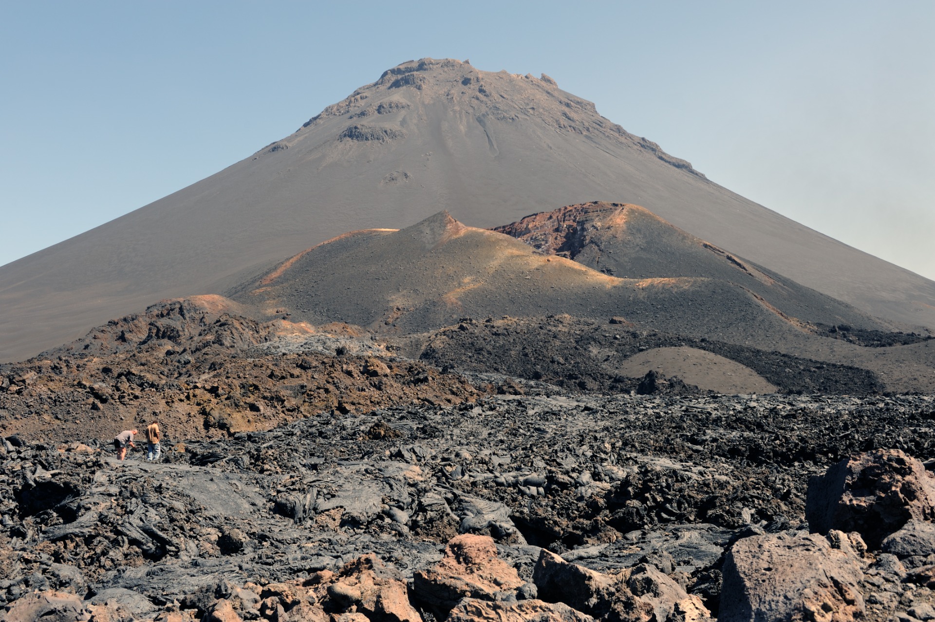
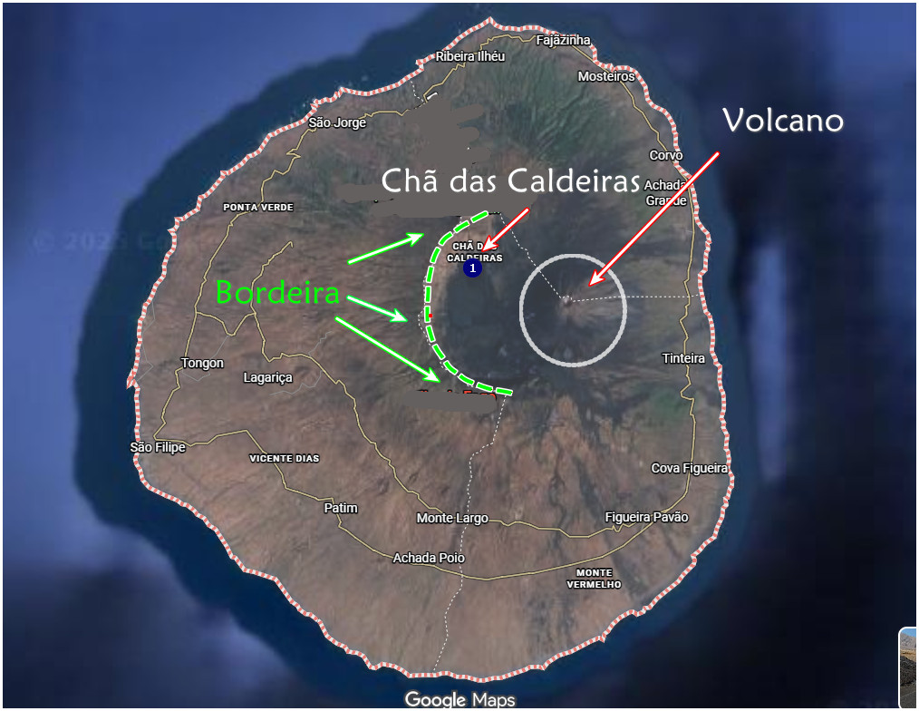
Nestled within the vast Cha Caldera at the base of Cape Verde's highest and most active volcano, Pico do Fogo (2,829 m), Chã das Caldeiras—meaning "Plain of the Calderas"—stands as a breathtaking testament to human resilience amid extreme natural forces. Enclosed by the sheer 1,000-meter escarpments of the Bordeira crater rim, this high-altitude plain spans roughly 40 km² and lies at approximately 1,700 meters above sea level, making it the highest settlement in the archipelago. Its cool, semi-arid BSk climate, with an average temperature of just 13.5 °C (56.3 °F), contrasts sharply with the tropical heat below, while the rich volcanic soil—formed from centuries of eruptions—creates an unexpectedly fertile environment. The entire area falls under the protected Fogo Natural Park (Parque Natural do Fogo), established in 2003 to safeguard its unique geological and ecological value. Administratively, the settlement belongs to the municipality of Santa Catarina do Fogo.
Villages and Community: A Legacy of Resilience and Heritage
The heart of Chã das Caldeiras beats in two closely connected villages: Portela (founded 1920) and Bangaeira (founded 1917), which have grown together into a single community often referred to as Povoação Chã das Caldeiras. Most residents share a common ancestry tracing back to François Louis Armand Fourcheut de Montrond, a French noble (sometimes called the Duke or Count of Montrond) who arrived on Fogo around 1870 after earlier French influence dating to 1670. He introduced viticulture, and many locals today—about half bearing the surname "Cha"—exhibit distinctive European features such as light skin, blue eyes, and blond hair, a striking contrast against the dark volcanic backdrop.
Before the 2014 eruption, nearly 1,000 people called Chã home. The population had nearly doubled since the 1995 eruption, reaching 964 just prior to the 2014–2015 event. Despite repeated destruction—most recently in 2014, when lava flows buried 95% of Portela and 90% of Bangaeira—the community has consistently returned to rebuild. This defiance stems from deep cultural ties to the land and an economic dependence on its unique agricultural potential, even as the government has banned permanent resettlement for safety reasons.
The 2014–2015 Eruption: Destruction and Defiance
The most recent major eruption began on November 23, 2014, and raged for 88 days until February 8, 2015. Lava covered 520 hectares, obliterating all homes, the local school, a health unit (opened in 2013), churches, the Pedra Brabo hotel and restaurant, the Fogo Natural Park headquarters, and 208 hectares of farmland. Nearly 994 residents were evacuated. Though the government prohibited rebuilding in the high-risk zone, many families returned illegally, reconstructing homes and vineyards in defiance of danger. This act of resilience has become symbolic of the community's identity—living not despite the volcano, but because of it.
An "Economy of Uncertainty" Built on Volcanic Bounty
Life in Chã das Caldeiras revolves around an integrated economy of uncertainty, balancing agriculture, livestock, remittances, and tourism against the ever-present threat of eruption and irregular rainfall.
Agriculture and Local Products
The volcanic soil—rich in minerals and well-drained—supports crops rarely viable elsewhere in Cape Verde. Farmers grow grapes, apples, pomegranates, figs, peaches, beans, corn, and raise goats for queijo de cabra (goat cheese) with its creamy, salty-spicy profile. Coffee and sweet potatoes also thrive. These products are not just sustenance—they define the region's identity and economy.
Wine: The Soul of Chã
Chã das Caldeiras is synonymous with wine. The Associação dos Agricultores de Chã, a cooperative of 102 members, produces the acclaimed Chã-labeled wines (white, red, rosé) and spirits under the Vinho do Fogo designation. In 2021, it earned a Protected Designation of Origin (PDO), recognizing the inseparable link between terroir and taste. Winemaking began with Montrond's vines and continues in cellars that double as storytelling spaces about Fogo's geological history. The cooperative's winery, built in 1998, was completely destroyed in 2014 but has since been rebuilt. Visitors can taste bold, mineral-driven wines—especially the iconic Manecom—directly with producers, often in rustic, welcoming settings.
VIDEO : report on the wine of Fogo island ( in portuguse)
Tourism: Adventure, Culture, and Recovery
Tourism has become a lifeline for Chã, transforming volcanic risk into a draw for adventure seekers. The area attracts nature-based, hiking, cultural, and ecological tourists, with Pico do Fogo as the island's star attraction.
Key Activities
- Climbing Pico do Fogo: The standard route starts early from Chã. The steep ascent takes 4–6 hours; the descent—running down soft volcanic ash—can be done in under an hour. Local guides are mandatory for safety and navigation.
- Exploring Subsidiary Craters: Easier hikes lead to Pico Pequeno (formed 1995) and Pico Novo (formed 2014). A round trip from Portela takes 2–3 hours.
- Crater Rim and Village Walks: Trails reveal dramatic lava fields, ochre rocks, and the "Martian" landscape. The 10 km descent to Mosteiros takes about 4 hours.
- Information Center: Located on the plain, it offers exhibitions on geology, history, and eruptions. Guides can be hired here.
Accommodation and Hospitality
Before 2014, 14 guesthouses offered 135 beds, many in traditional funcos—round, thick-walled stone houses. Though most were lost, reconstruction emphasizes small-scale, sustainable lodgings. A standout is Casa Marisa 2.0 (also Casa Mariza), centrally located between Portela and Bangaeira at nearly 1,700 m. Run by Marisa—a chef trained under a French mentor for eight years and formerly at the renowned Pedra Brabo restaurant—it blends Cape Verdean and French culinary traditions. Meals feature fresh plateau ingredients and Atlantic fish, with signature dishes like "Lava de Vulkan" dessert. The restaurant seats up to 50 and includes a café serving Fogo coffee and local wines.
Infrastructure: Living Off the Grid in a High-Risk Zone
Chã das Caldeiras remains deliberately off the public grid. There is no running water or electricity network—rainwater is collected in cisterns, and power comes from generators or solar panels. The absence of utility poles preserves the pristine night sky, a boon for stargazing tourists. Roads were severely damaged in 2014; though an asphalt link from São Filipe was built to boost tourism, sections inside the caldera remain cobblestone to maintain natural character—a decision by the Fogo Natural Park that has sparked local debate.
Access and Transport
The drive from São Filipe takes 1.5–2 hours. Aluguers (shared minibuses) run twice daily—mid-morning and afternoon—from São Filipe, returning at 6 a.m. and noon (no service on Sundays). Early departures require pre-arrangement with hosts. Private taxis cost 50–60 euros one way. The road climbs to the crater rim before zigzagging down into the plain.
