Fogo island - trekking and walking
The Fogo Island Trekking Guide: 4 Volcanic Trails You Can't Miss
There's something primal about hiking a volcano. The crunch of volcanic scoria under your boots, the sulfur smell drifting from hidden fumaroles, the knowledge that the ground beneath you was molten rock just years ago—it's hiking stripped down to its elemental core. Fogo Island, Cape Verde's volcanic heart, offers some of the most dramatic trekking in West Africa, and I'm here to break down the four essential walks that will make your visit unforgettable.
Whether you're after a gentle half-day crater stroll or a full-day rim traverse with exposure that'll make your palms sweat, this guide has you covered.
Climbing the volcano in Fogo island
The volccano climb is the island's premier attraction, drawing adventure travelers, volcano enthusiasts, and nature lovers from around the world.
The Ultimate Volcano Hike
The ascent of Pico do Fogo is the ultimate Fogo experience:
Route: The 8.2 km round trip starts in Chã das Caldeiras, gaining over 1,000 vertical meters. The ascent takes 4–6 hours (Difficult Level).
The Descent Hack: The fastest, most memorable part is ash surfing—running or sliding down the deep, soft volcanic ash/scree slopes in 90 minutes or less.
Safety: A local, certified guide (costing €25–50) is mandatory for the summit climb due to the steep, unstable terrain and potential for sudden weather or geological changes.
More volcanic trails in Fogo Island
1. Pico Pequeno & Pico Novo Circuit: The Perfect Introduction
The Short Version: A manageable 5.5 km loop through Fogo's most recent craters—ideal if you want volcanic drama without the full Pico do Fogo commitment.
What You're Getting Into
This circular route starts and ends in Portela village, right in the heart of Chã das Caldeiras. You'll circumnavigate two distinct volcanic cones: Pico Pequeno (the 1995 eruption site at 1,948 m) and Pico Novo (the 2014 "new peak" at 1,920 m). It's essentially a geology lesson with a workout attached.
The Numbers:
- Distance: 5.5 km
- Elevation: +220 m / -220 m
- Time: 2-3 hours at a photo-taking pace
- Difficulty: Easy to moderate
The Experience
From Portela, it's a 15-minute walk to the signed trailhead. The path weaves between compacted ash trails and loose scoria—that crunchy volcanic gravel that sounds like walking on cornflakes. There are short rocky scrambles, but nothing technical.
The highlight? Standing at the rim of Pico Novo's crater and peering into the still-warm interior. Ground temperatures here can hit 45-60°C, hot enough to make your phone unhappy if you set it down. You'll smell sulfur from active fumaroles—Earth's breath, basically—and if you're lucky, you might see wisps of steam rising from vents.
The panoramic views of the Caldeira are spectacular. You're standing on volcanic features that didn't exist 30 years ago, surrounded by a landscape that looks more Mars than Earth. The contrast between the black lava, the occasional splash of green vegetation, and the deep blue sky is photographer's gold.
Practical Intel
Access: From São Filipe, take an aluguer (shared minivan) to Chã das Caldeiras, then walk to Portela. Total travel time: about 45 minutes.
Guide Situation: Not mandatory, but I strongly recommend hiring a local guide (€15-20 shared). They know which fumarole zones are safe to approach and which ones will cook your shoes. Plus, the stories about living through the 2014 eruption are worth the price alone.
What to Bring:
- 1 liter of water per person (zero sources on trail)
- High-ankle hiking boots—the sharp lava will shred regular shoes
- SPF 50+ sunscreen (UV index regularly hits 11-13)
- Hat and sunglasses (no shade whatsoever)
Timing: Start early—6-9 AM is ideal. By midday, you're basically hiking inside an oven. Post-hike, reward yourself with coffee at Casa Marisa in the village.
Warning: Stay on marked paths inside Pico Novo. The ground looks solid but can hide hot spots. Also, Fogo Natural Park charges a small fee (€1-3 per person) collected at trailheads.
2. Caldeira Rim to Mosteiros: The Classic Descent

The Short Version: An 11 km one-way descent from the volcanic highlands to a black sand beach, passing through multiple climate zones and the 2014 lava flows.
What You're Getting Into
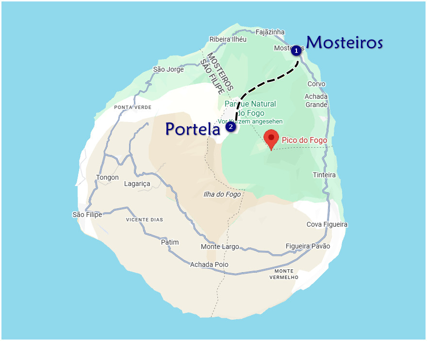
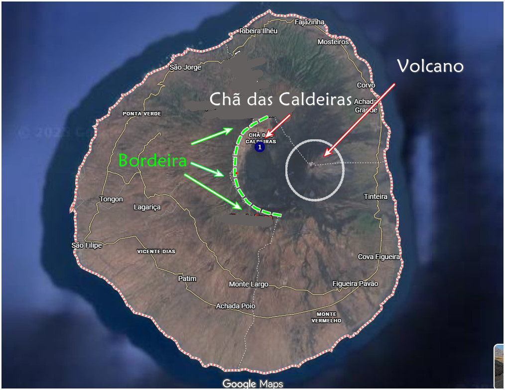
This is Fogo's signature trail—the Bordeira Trail that everyone talks about. You start at 1,700 meters on the Caldeira rim (Achada Furna) and descend all the way to sea level at Mosteiros village on the north coast. It's long, it's downhill, and it's absolutely unmissable.
The Numbers:
- Distance: 11.2 km
- Elevation: -1,700 m (mostly gradual)
- Time: 3.5-4.5 hours
- Difficulty: Moderate (your knees will have opinions)
The Experience
From the Achada Furna trailhead (about 1 km above Portela), you begin on the Bordeira rim with 360-degree views—the Caldeira on one side, the Atlantic on the other, and Pico do Fogo dominating the center. It's the kind of view that makes you stop walking and just stare.
The descent starts with ash and gravel switchbacks. Trekking poles aren't optional—they're essential. Your quads might be fine, but your knees will be screaming by kilometer eight if you don't have poles to distribute the impact.
Around the halfway point, you cross the 2014 lava flow—a river of frozen black stone that destroyed everything in its path. Walking over it feels surreal, like crossing a battlefield where Earth won against everything else.
The landscape transforms as you drop in elevation: volcanic wasteland → Monte Velha forest transition (suddenly there are trees!) → coffee groves → finally, a cobblestone road leading into Mosteiros, where a black sand beach awaits. Few hikes offer this much variety in under four hours.
Practical Intel
Access:
- Start: Arrange an aluguer or tour van from Chã to Achada Furna (€5-8 per person shared)
- End: Mosteiros has taxis back to São Filipe or ferry connections to Brava island
Guide Situation: Mandatory for groups over four people; recommended for everyone else (€30-40 including transport coordination). The trails aren't always obvious, and a guide ensures you don't end up on a dead-end goat path.
What to Bring:
- 2 liters of water per person (no water after kilometer 7)
- Trekking poles (seriously, don't skip these)
- Lunch or snacks (Mosteiros has restaurants, but arrive hungry)
- Layers—it's cool at the top, warm by the beach
Timing: Start between 7-8 AM. This gives you time to enjoy the hike without rushing, plus you'll avoid the afternoon sea fog that can obscure the coastal path.
Critical Note: Book your return transport from Mosteiros the day before. Don't assume you'll find a taxi waiting—this is Cape Verde, not Switzerland.
Best Season: Avoid July-September (rainy season). The trail gets muddy and slippery. November-May is prime time.
3. Monte Velha Forest Traverse: Fogo's Green Secret

The Short Version: A 9 km loop through Fogo's unexpected cloud forest—think misty ridges, endemic birds, and the chance to taste local grogue at a distillery.
What You're Getting Into
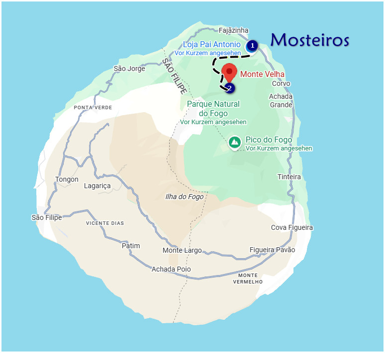
If someone told you there's a lush, dripping-wet cloud forest on a volcanic island in the middle of the Atlantic, you'd probably doubt them. But here it is: Monte Velha, Fogo's green secret, hiding above Mosteiros village at 850 meters elevation.
This circular route is a complete contrast to the lunar landscapes of the Caldeira. You'll hike through banana, papaya, and mango groves, climb muddy forest trails with root steps, and cross coffee plantations where locals still harvest beans the old way.
The Numbers:
- Distance: 9 km
- Elevation: +1,050 m / -1,050 m
- Time: 6-7 hours (slow pace for birding and photos)
- Difficulty: Moderate to strenuous (steep sections both ways)
The Experience
Starting from the church in Pai Antonio village, the trail immediately climbs into the forest. This isn't just "some trees"—it's proper cloud forest with eucalyptus shade, mist rolling through the canopy, and a completely different vibe from the rest of Fogo.
The forest is home to endemic birds, including the Fogo sparrow and Fogo swift. If you're into birding, bring binoculars and patience. The misty ridges create a moody, almost mystical atmosphere—perfect for photography if you're into that Tolkien aesthetic.
A highlight many guides include: stopping at local homesteads where they make grogue, Cape Verde's potent sugarcane rum. Dona Ana's place is legendary—fresh coffee and a shot of grogue while sitting in her garden overlooking the valley. It's the kind of authentic experience you can't plan; you just have to follow where the trail leads.
Practical Intel
Access: Take an aluguer from Mosteiros to Pai Antonio (€3 per person). The trailhead is at the village church.
Guide Situation: Strongly advised (€25). The trails are unmarked and cross private land. A local guide smooths out the permission issues and knows where you're actually allowed to walk.
What to Bring:
- Long pants (leeches after rain—yes, really)
- Gaiters or spare socks (muddy conditions)
- Salt (for leech removal if needed)
- Packed lunch (no facilities)
- 2 liters of water
Timing: October-December is the sweet spot—post-rain, maximum greenness. Start at 7 AM to catch the morning mist before it burns off.
Special Tip: Ask your guide to stop at Dona Ana's for coffee and grogue. It's an unofficial highlight that makes the whole hike worth it.
4. Bordeira Rim Traverse: The Full Circle Epic

The Short Version: An 18-20 km ridge walk around the entire Caldeira rim—continuous volcano views, serious exposure, and the kind of hike that earns bragging rights.
What You're Getting Into
This is Fogo's big boy hike—the full Caldeira circuit along the Bordeira rim from Portela to Bangaeira. If you want 360-degree volcanic panoramas for an entire day, this is your trail. It's also the most exposed, the longest, and the most potentially dangerous if conditions aren't right.
The Numbers:
- Distance: 18-20 km
- Elevation: +900 m / -950 m (constant undulation)
- Time: 7-9 hours
- Difficulty: Strenuous (exposure, length, and stamina required)
The Experience
You're walking the rim of a massive volcanic crater for an entire day. On your right: the Caldeira floor, 1,000 meters below, with Pico do Fogo rising from its center. On your left: cliffs dropping to the ocean. In front of you: a narrow ridge path, loose scree, and sections where you're very aware there are no guardrails.
The trail is relentlessly scenic. Every turn brings another jaw-dropping view. If you visit in November, the ridges explode with wildflowers—unexpected splashes of yellow and purple against the volcanic black and brown.
There's one section with a short (3-meter) exposed step where guides carry rope for nervous hikers. It's optional—you can scramble it without—but the drop-off is real, and some people appreciate the safety line.
You can add a spur to Pico Pequeno if you're feeling ambitious (or masochistic), but most people stick to the main rim trail.
Practical Intel
Access:
- Start: Walk from Chã das Caldeiras to Portela
- End: Aluguer from Bangaeira back to Chã (€8)
Guide Situation: Mandatory. Absolutely mandatory. The cliff exposure is serious, there's zero signage, and if you get caught in a cloud inversion (which happens), you won't see the path. Guides charge €50-70 per person and are worth every euro.
What to Bring:
- 3 liters of water per person (this is a long day with no sources)
- Full lunch and snacks
- Wind jacket (gusts can exceed 40 km/h)
- Trekking poles
- Extra layers (temperature can drop fast)
Timing: November-May only. Start at 6 AM—you need the full day. Check the wind forecast before committing; winds over 40 km/h make this hike genuinely dangerous.
Safety Notes:
- Drop-offs with no barriers—stay focused
- High wind exposure—don't underestimate this
- Cloud inversions can hide the path entirely
- Guides carry rope for the one exposed scramble
Emergency Contact: Save this WhatsApp number: Casa Alcinda (+238 992 12 34). Cell signal is patchy on the ridges, but it exists in some spots.
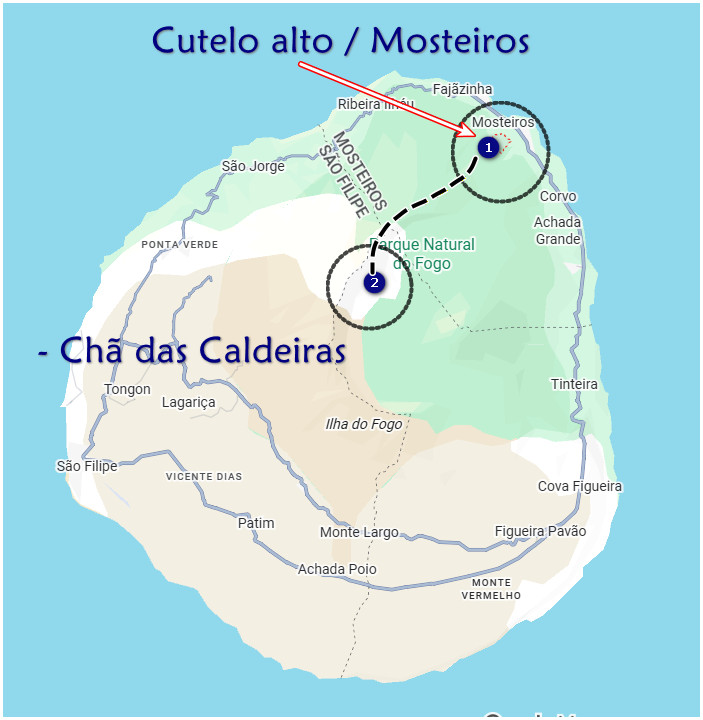
Hike: Cutelo alto / Mosteiros - Chã das Caldeiras

Essential Fogo Trekking Tips
Water Strategy
There are zero water sources above 1,000 meters elevation. Plan accordingly. I carry a 3-liter bladder for long hikes and a 1-liter bottle for shorter ones. Dehydration on a volcano is not the adventure you want.
Sun Protection
The UV index on Fogo regularly hits 11-13—year-round. I'm talking "you will burn through your shirt" levels. SPF 50+ sunscreen is mandatory, not optional. Reapply every two hours. Wear a wide-brimmed hat. Sunglasses are essential.
Footwear
High-ankle hiking boots with good grip (Salomon, Vibram soles, or equivalent). The lava is sharp enough to shred regular shoes, and the loose scoria requires ankle support. I learned this the hard way with a pair of trail runners that lasted exactly one hike.
Fogo Natural Park Fee
Expect to pay €1-3 per person at trailheads. It's collected by rangers or guides and goes toward park maintenance. Have small change ready.
Cell Signal
Patchy at best on the ridges and inside the Caldeira. Don't count on calling for help. This is another reason guides are valuable—they know the dead zones and have backup communication plans.
Best Overall Season
November to May is prime trekking season. Dry weather, stable temperatures, and clearer visibility. Avoid July-September (rainy season) unless you enjoy mud wrestling and zero views.
Final Thoughts: Why Trek Fogo?
Treeking and walking in Fogo holds its own. It's not the highest or the longest, but it's the most geologically alive. You're walking on Earth's newest creations, through landscapes that didn't exist a generation ago, surrounded by people who chose to rebuild their homes on an active volcano because it's home.
The trails here aren't well-marked European paths with signposts every 100 meters. They're raw, sometimes exposed, and require respect. But that's exactly what makes them special. You're not just a tourist—you're an explorer, walking where fire meets rock meets ocean, in one of the Atlantic's most dramatic settings.
Whether you choose the gentle Pico Pequeno loop or commit to the full Bordeira rim traverse, you'll leave Fogo with volcanic dust in your boots, incredible photos, and the kind of stories that make people lean forward when you tell them.
Just remember: hire a local guide, start early, carry more water than you think you need, and respect the volcano. It's been sleeping since 2014, but it's not extinct—just resting.
Exploring Fogo's Lava Tubes: The Underground Adventure You Didn't Know You Needed
Everyone comes to Fogo to climb up the volcano. But what if I told you some of the island's most fascinating geology is underground? Hidden beneath the vineyards of Chã das Caldeiras is a network of lava tubes—tunnels carved by rivers of molten rock during past eruptions. These aren't tourist-trap caves with LED lights and handrails. These are raw, pitch-black volcanic chambers where you'll descend steel ladders, squeeze through narrow passages, and emerge covered in volcanic dust with a story nobody else at home will have.
